


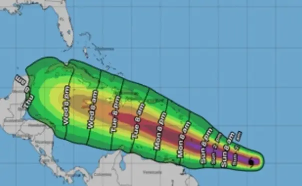
El sábado, la tormenta tropical Beryl se convirtió en un huracán de categoría uno, encontrándose a 1,160 kilómetros al este/sureste de Barbados. La Oficina Nacional de Meteorología (Onamet) reportó que las lluvias de hoy no están relacionadas con Beryl, sino con una vaguada. A pesar de que el huracán no representa un peligro para el país debido a su posición, Onamet llamó a los ciudadanos a estar atentos a los boletines de las autoridades, ya que, según la trayectoria proyectada, se espera que el fenómeno pase cerca de Barahona en aguas del Mar Caribe. Los pronósticos indican que Beryl se sentirá a partir del martes por la mañana. Hasta el momento, el Centro de Operaciones de Emergencias (COE) no ha emitido ninguna alerta relacionada.
Por otro lado, Hurricane Beryl has decreased in intensity again after reaching Category 1 status earlier. The National Hurricane Center reported this on Monday, stating that the hurricane has maximum sustained winds of 75 mph and is located about 725 miles east-southeast of Barbados. Beryl is moving at a fast pace of 14 mph, which is expected to continue and could result in a decrease in strength over the next 48 hours. Despite this decrease in intensity, tropical conditions are still expected in certain areas, and authorities are urging citizens to remain vigilant and prepared for potential changes in the storm’s path.
It is important to note that the Emergency Operations Center (COE) has not issued any alerts so far, as the projected trajectory of Hurricane Beryl does not pose a direct threat to the Dominican Republic. However, authorities are closely monitoring the situation and advising residents to stay informed through official bulletins and updates. Beryl’s movement is being closely tracked to determine any potential impacts on the country, especially in regions near the Caribbean Sea where the hurricane is expected to pass through.
As the hurricane season progresses, it is crucial for individuals to have emergency plans in place and to stay informed about weather developments in their region. While Hurricane Beryl may not directly impact the Dominican Republic, the possibility of changes in its trajectory or intensity underscores the need for preparedness and vigilance. The National Meteorological Office (Onamet) continues to provide updates and warnings related to tropical storms and hurricanes, ensuring that the population is aware of any potential risks and can take the necessary precautions to protect themselves and their communities.
In light of the current situation with Hurricane Beryl, local authorities and emergency response teams are on high alert and ready to take action if necessary. The coordination between government agencies, civil defense organizations, and other stakeholders is essential in ensuring a swift and effective response to any potential emergencies. By staying informed, following official guidelines, and being prepared for adverse weather conditions, individuals can enhance their safety and resilience in the face of natural disasters like hurricanes. While the direct impact of Beryl on the Dominican Republic may be minimal, the country remains vulnerable to tropical storms and other extreme weather events, highlighting the importance of proactive measures to mitigate risks and ensure the well-being of all citizens.


